Membership / Renewal Form
पुरानो वेबसाइट हेर्नुहोस
English
नेपाली
+९७७-१ ५९१४७८५, ५९१४७२३
[email protected]
गृहपृष्ठ
सदस्य संख्या
महासंघकाे निर्वाचन - २०८१
निर्वाचन कार्यविधि
मतदाता नामावली, प्रकाशन मिति : २०८१ मङ्सिर १८ गते
उम्मेदवारको अन्तिम मत परिणाम प्रकासन गरिएको सम्बन्धमा ।
नवनिर्वाचित केन्द्रीय समितिकाे नामावली तथा सम्पर्क विवरण
हाम्रो बारेमा
परिचय
नेपाल पत्रकार महासंघको विधान २०६० (पाँचौ संशोधन २०७५)
रणनीति
नीतिहरू
कार्यसमिति
नेपाल पत्रकार महासंघ, केन्द्रीय समिति
प्रदेश समिति
जिल्ला तथा शाखा अध्यक्ष
केन्द्रीय कार्यालयका कर्मचारी
केन्द्रीय समितिको सम्पर्क विवरण
फोटो ग्यालरी
प्रकाशन
आर्थिक गतिविधि
सम्पर्क
उजुरी
गृहपृष्ठ
सदस्य संख्या
महासंघकाे निर्वाचन - २०८१
निर्वाचन कार्यविधि
मतदाता नामावली, प्रकाशन मिति : २०८१ मङ्सिर १८ गते
उम्मेदवारको अन्तिम मत परिणाम प्रकासन गरिएको सम्बन्धमा ।
नवनिर्वाचित केन्द्रीय समितिकाे नामावली तथा सम्पर्क विवरण
हाम्रो बारेमा
परिचय
नेपाल पत्रकार महासंघको विधान २०६० (पाँचौ संशोधन २०७५)
रणनीति
नीतिहरू
कार्यसमिति
नेपाल पत्रकार महासंघ, केन्द्रीय समिति
प्रदेश समिति
जिल्ला तथा शाखा अध्यक्ष
केन्द्रीय कार्यालयका कर्मचारी
केन्द्रीय समितिको सम्पर्क विवरण
फोटो ग्यालरी
प्रकाशन
सदस्यहरू
आर्थिक गतिविधि
सम्पर्क
उजुरी
शुद्धीकरण समितिले निर्धारण गरेको मापदण्डअनुसार प्रदेश समितिबाट प्रस्तावित सदस्यका नाम सार्वजनिक गरिएको सूचना
समाचार
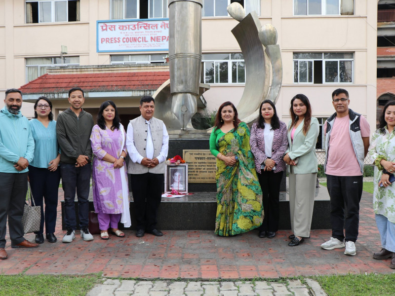
जनपक्षीय पत्रकार तथा प्रगतिशील साहित्यकार कृष्ण सेन ‘इच्छुक’को २४औं स्मृति दिवसका अवसरमा आज नेपाल पत्रकार महासंघले सञ्चारग्रामस्थित पत्रकार स्मृति स्तम्भमा श्रद्धाञ्जली व्यक्त गरेको छ ।
पूर्ण प्रेस स्वतन्त्रता, श्रमजीवी पत्रकारको हित र सरकारी विज्ञापन वितरणमा निजी सञ्चारमाध्यममाथि भइरहेको विभेद अन्त्य गर्न महासंघको ध्यानाकर्षण पत्र
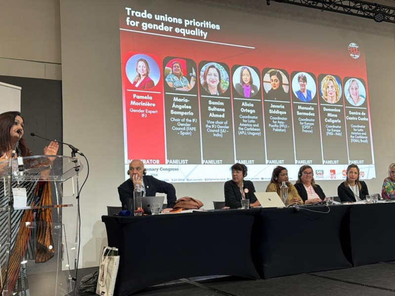
मे ४ देखि ७ सम्म पेरिसमा सम्पन्न अन्तर्राष्ट्रिय पत्रकार महासंघको विश्व सम्मेलनमा सम्बोधनका क्रममा नेपाल पत्रकार महासंघका अध्यक्ष निर्मला शर्मा।
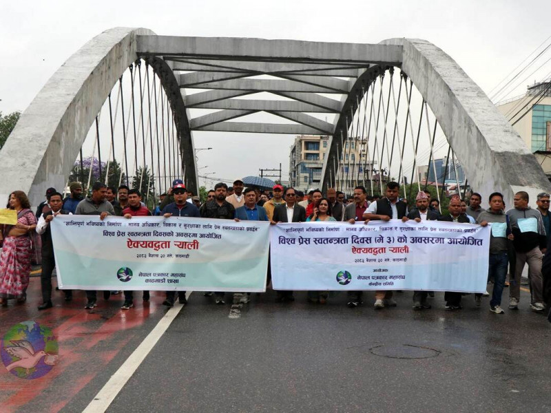
विश्व प्रेस स्वतन्त्रता दिवस (मे ३) को अवसरमा नेपाल पत्रकार महांघद्वारा आयोजित ऐक्यबद्धता ¥याली
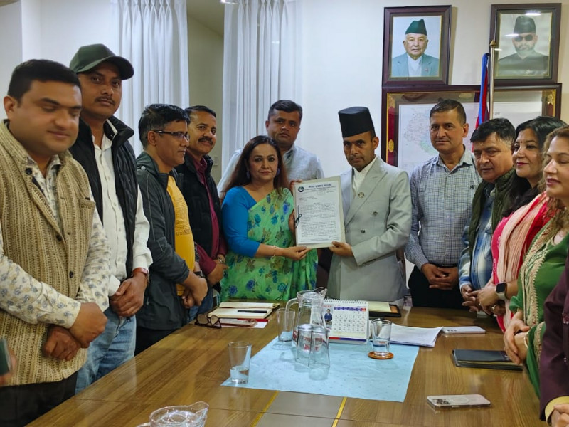
नेपाल पत्रकार महासंघले सञ्चार तथा सूचना प्रविधिमन्त्री डा.बिक्रम तिमिल्सिना लाई भेटेर सरकारले सरकारी सञ्चारमाध्यममा मात्र सरकारी सूचना प्रकाशन र प्रसारण गर्ने निर्णय र नेपाली सञ्चारमाध्यमको समस्याका बारेमा सरकारलाई ज्ञापनपत्र बुझाएकाे छ
सबै समाचार हेर्नुहोस
प्रेस विज्ञप्ति
सबै हेर्नुहोस
नेपाल पत्रकार महासंघले सूचना र विज्ञापनसम्बन्धी विभेदकारी र स्वेच्छाचारी सरकारी निर्णय खारेजी, प्रेसको संवैधानिक हकको रक्षाका साथै संसदबाटै सर्वपक्षीय कार्यदल गठन गरी संंविधान संशोधनको पहल र निर्वाध सूचना उपभोगको सुनिश्चितताका लागि थप दबाबमूलक आन्दोलन घोष
New
पत्रकार नरेन्द्र महतोको सञ्चार सामग्री खोसिएको घटनाप्रति नेपाल पत्रकार महासंघको ध्यानाकर्षण
New
दर्शनखबर डटकमका सम्पादक चिन्तामणि कँडेललाई निर्माण व्यवसायी सुरज थापाले कुटपिट गरी घाइते बनाएकोमा नेपाल पत्रकार महासंघको ध्यानाकर्षण
New
जेठ १४ गते सम्पादकीय वा अन्य स्थानमा कालो राख्ने निर्णय भएबमोजिम गरी/गराई आन्दोलनमा ऐक्यवद्धता प्रकट गरिदिनुहुन नेपाल पत्रकार महासंघ देशका सबै सञ्चारमाध्यमलाई आहृवान
New
सूचना
सबै हेर्नुहोस
नेजा ग्रामीण उत्कृष्ट पत्रकारिता पुरस्कार– २०२४, दरखास्त आह्वान -
२०८२ चैत्र १९
बेस्ट मिडिया अवार्डका लागि आवेदन आह्वान -
२०८२ आश्विन १०
Terms of Reference (ToR) का लागि म्याद थप सम्बन्धी सूचना -
२०८२ आषाढ ०१
Terms of Reference (ToR) -
२०८२ जेठ २३
सुचना अधिकारी
प्रेस स्वतन्त्रता रिपोर्ट
सबै हेर्नुहोस
प्रेस स्वतन्त्रता र पत्रकार सुरक्षा वार्षिक प्रतिवदेन - २०८३
प्रतिवेदन
२०८३ बैशाख २१
Press freedom violations in 2025: Nearly three times more incidents than the previous year
प्रतिवेदन
२०८२ पौष १६
Press Freedom Report: 2024
प्रतिवेदन
२०८१ पौष २६
प्रेस स्वतन्त्रता हननको डेटाबेस
स्टोरी पोस्ट गर्नुहोस्
स्टोरी पोस्ट गर्नुहोस्
स्टोरीहरू हेर्नुहोस
फोटो ग्यालरी
View All
लोकतन्त्र सुदृढीकरणः नागरिक सरोकार, सहभागिता र जावफदेहिता विषयमा महासंघको राष्ट्रिय कार्यशाला गोष्ठीका क्रममा लिइएका तस्विर ।
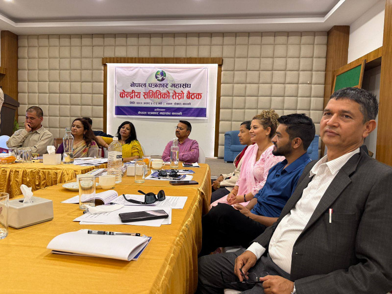
नेपाल पत्रकार महासंघ, केन्द्रीय समितिको २०८२ असार ५ र ६ गते पाेखरामा सम्पन्न तेस्रो पूर्ण बैठक
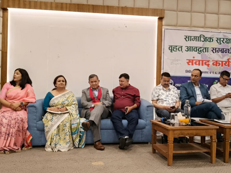
नेपाल पत्रकार महासंघ, केन्द्रीय समितिले पोखरामा आयोजना गरेको 'सामाजिक सुरक्षा कोषमा वृहत् आवद्धता' सम्बन्धी पत्रकारसँग संवाद कार्यशाला
विश्व प्रेस स्वतन्त्रता दिवस २०२५ का अवसरमा नेपाल पत्रकार महासंघद्वारा आयोजित कार्यक्रमका केही तस्विर ।
भिडियो ग्यालरी
सबै हेर्नुहोस
आर्थिक गतिविधि
सबै हेर्नुहोस
DAMAN CCM FiINANCIAL REPORT April- September , 2021
Kapilvastu CCM meeting Financial- August- December 2021
FNJ, Financial Report presented at Nagarkot Meeting, Jan-July, 2022
Follow Us On Facebook
Follow Us On X
Posts by FNJNepal